Tropical Cyclone Lusi has spawned warnings and watches in the Solomon Islands, Vanuatu, and New Zealand as it moves through the South Pacific Ocean. NASA's Terra and Aqua satellites provided visible and infrared views of the storm that revealed it has become better organized.
NASA's Terra satellite captured a visible image of Tropical Cyclone Lusi over Vanuatu on March 9 at 23:30 UTC. The image showed towering thunderstorms surrounded the center and northwestern quadrants of the storm.
The next day at 02:17 UTC, NASA's Aqua satellite passed over Lusi and captured infrared data on the storm that showed the thunderstorms rose high into the troposphere. The strongest thunderstorms had cloud top temperatures as cold as -63F/-52C. Multispectral satellite imagery showed that Lusi continued to consolidate and strong thunderstorms continue to develop. Those thunderstorms are wrapping into the center of circulation.
NASA and JAXA's Tropical Rainfall Measuring Mission satellite provided a microwave look at Lusi at 05:31 UTC/1:31 a.m. EST and showed the system continues to consolidate. TRMM data showed bands of strong thunderstorms had wrapped tightly around the center, and that the bulk of the deep convection is within the storm's northwestern quadrant.
Lusi has spawned several watches and warnings. In the Solomon Islands a tropical cyclone watch is in effect for Temotu, Makira, Rennell and Bellona, as well as the southern Guadalcanal and Malaita provinces.
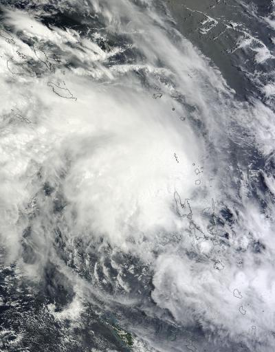
NASA's Terra satellite captured this visible image of Tropical Cyclone Lusi over Vanuatu on March 9 at 23:30 UTC.
(Photo Credit: NASA Goddard MODIS Rapid Response Team)
In Vanuatu, gale force winds were expected to continue to affect Torba, Sanma, Penama and Malampa Provinces on March 10 and 11 as the storm pushes south. The Vanuatu Meteorological Service expects very rough seas and heavy swells throughout Vanuatu. They noted that heavy rainfall and flooding are also expected over low lying areas and areas close to river banks on March 10. For further updates from the Vanuatu Meteorological Services, visit: http://www.meteo.gov.vu.
Farther south, New Zealand is already anticipating effects from Lusi. The Met Service of New Zealand noted in their discussion on March 10, that once Lusi moves closer "it could bring a spell of wet and windy weather especially to parts of northern New Zealand by the weekend." For further updates from the New Zealand Met Service, visit: http://www.metservice.com/.
On March 10 at 0900 UTC/5 a.m. EST, Tropical Cyclone Lusi had maximum sustained winds near 45 knots/51.7 mph/84.4 kph. It was centered near 15.0 south latitude and 166.7 east longitude, about 433 nautical miles/498.3 miles/801.9 km north of Noumea, New Caledonia. Lusi was moving to the west-southwest at 4 knots/4.6 mph/7.4 kph.
The Joint Typhoon Warning Center expects Lusi to run into cooler waters and increasing vertical wind shear that will help weaken the storm and transition it into an extra-tropical storm.
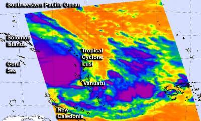
On March 10 at 02:17 UTC, NASA's Aqua satellite passed over Lusi and the AIRS instrument captured infrared data on the storm that showed the thunderstorms (with cloud top temperatures as cold as -63F/-52C) rose high into the troposphere.
(Photo Credit: NASA JPL, Ed Olsen)
Source: NASA/Goddard Space Flight Center