The tenth tropical cyclone of the Southern Pacific Ocean cyclone season was born today, January 17 as NASA's Aqua satellite captured infrared data on the storm as it became Tropical Storm June.
NASA's Aqua satellite passed over Tropical Cyclone June at 02:41 UTC. The Atmospheric Infrared Sounder or AIRS instrument captured infrared data and temperature information about June, and it was used to create a false-colored image at NASA's Jet Propulsion Laboratory in Pasadena, Calif. The AIRS image showed the center of June between the Solomon Islands to the northwest, New Caledonia to the southeast and Vanuatu to the east. Thunderstorms around the center and mostly over open waters were dropping heavy rainfall. AIRS data showed that those thunderstorms had cloud top temperatures in excess of -63F/-52C indicating they were high in the troposphere and powerful.
On June 17, a tropical cyclone Watch is in effect for Norfolk Island. Northern New Caledonia and the community of Thio are now on an Amber Alert, while the remainder of the territory is on Yellow Alert.
On January 17 at 1500 UTC/10 a.m. EST, the Joint Typhoon Warning Center or JTWC noted that June was centered near 18.8 south latitude and 163.0 east longitude, about 294 nautical miles/338.3 miles/544.5 km southeast of Noumea, New Caledonia.
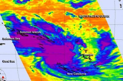
NASA's Aqua satellite passed over Tropical Cyclone June at 02:41 UTC between the Solomon Islands to the northwest, New Caledonia to the southeast and Vanuatu to the east. Powerful thunderstorms had cloud top temperatures in excess of -63F/-52C (purple).
(Photo Credit: Image : NASA JPL/Ed Olsen)
June's maximum sustained winds were near 35 knots/40 mph/62 kph and the storm is expected to strengthen slightly over the next several days. The JTWC forecasts June to pass just west of New Caledonia on January 17 and 18.
Microwave satellite imagery from the AMSU-B instrument coupled with infrared satellite data showed that the low-level circulation center is slightly elongated. Strong bands of convective thunderstorms persist in the eastern quadrant of the storm.
June is in an area that has moderate vertical wind shear, blowing as high as 20 knots and is forecast to increase in two days, which is expected to prevent June from strengthening a lot more. By January 19 as June continues southward it will also run into cooler waters which will sap its strength and help transition the storm to an extra-tropical one.
Forecasters at JTWC noted that June is moving along the western edge of a subtropical ridge (elongated area) of high pressure located east of the tropical storm. With the ridge guiding the system, JTWC's forecast track takes a weakened June to the northwestern tip of New Zealand by January 20.
Source: NASA/Goddard Space Flight Center