As Tropical Depression Peipah continues moving toward the central Philippines, NASA's Aqua satellite passed overhead and took an infrared look at the cloud top temperatures for clues about its strength.
On April 8 at 05:11 UTC/1:11 a.m. EDT/11 p.m. Manila local time, the Atmospheric Infrared Sounder instrument known as AIRS gathered infrared data on Tropical Depression Peipah. AIRS is one of the instruments that flies aboard NASA's Aqua satellite. The AIRS data showed thunderstorms with very cold cloud-top temperatures surrounded the center of the low-level circulation and in a band of thunderstorms extending south to southwest of the center. AIRS data showed cloud top temperatures exceeded -63F/-52C, which indicates they are high in the troposphere and have the potential for heavy rainfall. An infrared image from the data was created at NASA's Jet Propulsion Laboratory in Pasadena, Calif. and showed that Peipah was almost half the size of the Philippines.
At 0900 UTC/5 a.m. EDT/5 p.m. Manila local time, Tropical Depression Peipah, known as Domeng in the Philippines had maximum sustained winds near 30 knots/34.5 mph/55.5 kph, so it had only intensified by 5 knots/5.7 mph/9.2 kph in the last 24 hours. However, forecasters at the Joint Typhoon Warning Center expect Peipah to continue intensifying before making landfall in Visayas, or the central Philippines. Peipah was located near 8.0 north and 130.6 east, about 670 nautical miles/771 miles/1,241 km east-southeast of Manila, Philippines and moving to the north-northwest at 9 knots/10.3 mph/16.6 kph.
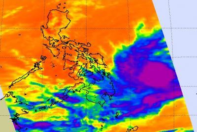
On April 8, the AIRS instrument aboard NASA's Aqua satellite showed thunderstorms with very cold cloud-top temperatures (purple) around Tropical Depression Peipah's low-level center and in a band of thunderstorms south to southwest of the center.
(Photo Credit: Image : NASA JPL/Ed Olsen)
A Tropical Cyclone warning remains in effect for shipping interests in the Philippine Sea. For the shipping warnings, visit: http://www.pagasa.dost.gov.ph/weather/shipping-forecast. PAGASA, the Philippine Atmospheric, Geophysical and Astronomical Services Administration, noted that estimated rainfall amounts range from 5 to 15 mm per hour within the 400 km diameter of the Tropical Depression's center.
Peipah is moving slowly northwest toward the Philippines and the Joint Typhoon Warning Center expects landfall by April 11.
Source: NASA/Goddard Space Flight Center