When NASA's Aqua satellite passed over Tropical Storm Soulik in the Northwestern Pacific Ocean, the MODIS and AIRS instruments captured images that showed the storm's eastern quadrant covered the Marianas Islands and that the storm has become more organized in the last day.
The MODIS or Moderate Resolution Imaging Spectroradiometer instrument that flies aboard NASA's Aqua satellite captured a brilliant visible image of Storm Soulik over the Mariana Islands on July 8 at 3:50 UTC (July 7 at 11:50 p.m. EDT). In the image, Soulik's center could be seen near the northern islands, just west of the long band of thunderstorms covering the island chain.
Around the same time, another instrument aboard Aqua called "AIRS," or Atmospheric Infrared Sounder captured an infrared look at Soulik. The AIRS infrared data measured cloud top temperatures. AIRS data showed that strong thunderstorms with cloud tops extending high into the troposphere had temperatures as cold as -63F/-52C, and packed the potential for heavy rainfall.
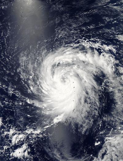
This visible image from July 8 at 3:50 UTC was taken by the MODIS instrument that flies aboard NASA's Aqua satellite shows Tropical Storm Soulik over the Mariana Islands.
(Photo Credit: NASA Goddard MODIS Rapid Response Team)
Infrared satellite imagery also showed that Soulik continues to consolidate quickly and it has tightly curved bands of thunderstorms that are wrapping around an eye-like feature near the center of the storm. Satellite microwave imagery showed the eye feature clearly.
On July 8, at 1500 UTC (11 a.m. EDT) Soulik had maximum sustained winds near 55 knots (63 mph/102 kph). Soulik's center was located near 9.2 north latitude and 142.0 east longitude, about 350 nautical miles south-southeast of Iwo Jima. Soulik is moving to the west at 10 knots (11.5 mph//18.5 kph).
Forecasters at the Joint Typhoon Warning center noted that the storm is expected to intensify, and may intensify rapidly. It could reach typhoon strength by tomorrow, July 9.
Soulik is moving away from the Marianas Islands and is expected to continue in a west, then west-northwesterly direction over the next several days. Soulik is currently forecast to track north of the Philippines, and affect northern Taiwan before making landfall in southeastern China (in the Zhejiang Province) later in the week.
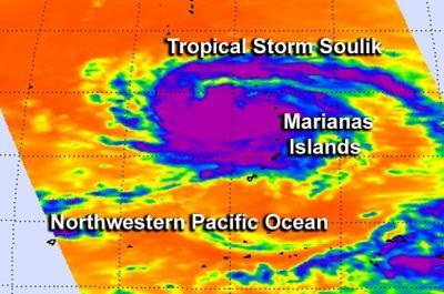
This infrared image from July 8 at 3:41 UTC was taken by the AIRS instrument that flies aboard NASA's Aqua satellite shows Tropical Storm Soulik over the Mariana Islands. The strongest thunderstorms with coldest cloud tops appear in purple.
(Photo Credit: NASA JPL, Ed Olsen)
Source: NASA/Goddard Space Flight Center