NASA's Aqua satellite provided visible and infrared satellite imagery to forecasters helping confirm the birth of the sixth tropical cyclone of the Northern Indian Ocean cyclone season.
Tropical Cyclone 06B, which may be renamed "Madi," organized from low pressure System 92B today, December 6, when it was about 266 nautical miles/306 miles/492.6 km southeast of Chennai, India. Tropical Cyclone 06B was centered near 9.8 north latitude and 93.7 west longitude. Its maximum sustained winds were near 45 knots/51.7 mph/83.3 kph, making it tropical-storm strength. Those tropical storm force winds extended out 50 nautical miles/57.5 miles/92.6 km from the center, making the small tropical storm just about 100 nautical miles/115.1 miles/185.2 km in diameter. 06B was moving to the northwest at 3 knots/3.4 mph/5.5 kph.
NASA's Aqua satellite passed over the tropical cyclone on December 5 at 20:17 UTC/3:17 p.m. EST. Strong rising air (convection) was building over the low-level circulation center and continued on December 6. AIRS data showed high, strong, cold thunderstorm cloud top temperatures as cold as -62F/-52C over a large area around the center and in a band wrapping into the center from the south.
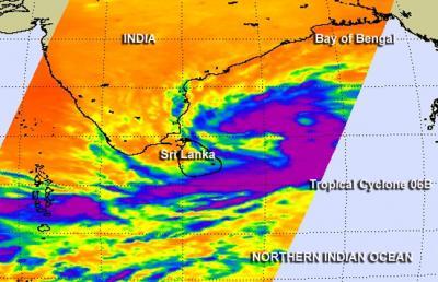
Aqua satellite passed over the tropical cyclone on Dec. 5 at 20:17 UTC/3:17 p.m. EST. Strong rising air and thunderstorms (purple) were building over the low-level circulation center and in a band of thunderstorms wrapping to the southwest.
(Photo Credit: Image : NASA JPL, Ed Olsen)
The forecasters at the Joint Typhoon Warning Center or JTWC expect 06B to continue strengthening over the next couple of days because it is located in warm waters.
06B is expected to drift northward because there are no weather systems to guide it until a low to mid-level subtropical ridge (elongated area) of high pressure builds up over the eastern Bay of Bengal. Once that happens, the tropical cyclone is expected to curve to the north-northeast.
JTWC forecasters also expect that 06B will briefly reach cyclone/hurricane strength sometime on December 9 as it parallels the coast of east-central India while remaining far off-shore.
Source: NASA/Goddard Space Flight Center