Former Hurricane Odile may be a bad memory for Baja California, but the remnants have moved over New Mexico and Texas where they are expected to bring rainfall there. NASA's TRMM satellite measured Odile's heavy rainfall rates on Sept. 18, and NOAA's GOES-West satellite saw the clouds associated with the former storm continue to linger over the U.S. Southwest on Sept. 19.
The remnants of Hurricane Odile were dropping heavy rain in the area from southern Arizona to western Texas when NASA-JAXA's Tropical Rainfall Measuring Mission or TRMM satellite flew over on September 18, 2014 at 0723 UTC (00:20 PDT). Some rain was found by TRMM's Precipitation Radar (PR) instrument to be falling at a rate of over 111 mm (4.4 inches) per hour in one downpour east of El Paso, Texas. A 3-D look with TRMM PR found that a few thunderstorm tops were pushing to heights above 13 km (8 miles) that were dropping heavy rainfall.
The GOES-West infrared image was taken on Sept. 19 at 11:15 UTC (7:15 a.m. EDT) showed a large area of clouds associated with the remnants over New Mexico and Texas. The image was created by the NASA/NOAA GOES Project at NASA's Goddard Space Flight Center in Greenbelt, Maryland.
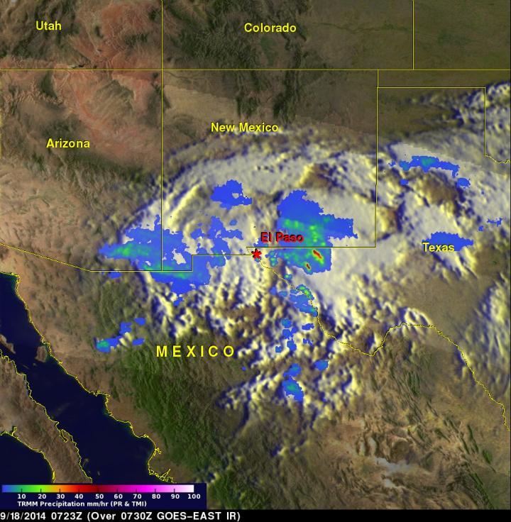
On Sept. 18, The TRMM satellite saw rain falling at a rate of over 111 mm (4.4 inches) per hour in one downpour east of El Paso, Texas. A few thunderstorm tops were pushing to heights above 13 km (8 miles) that were dropping heavy rainfall.
(Photo Credit: Image : NASA/SSAI, Hal Pierce)
The National Weather Service (NWS) cautioned on the morning of Sept. 18 that heavy rainfall from the remnants of Odile will continue to impacts parts of New Mexico and Texas into the early weekend (Sept. 20-21).
Odile's remnant center is expected to keep moving eastward into New Mexico and then western Texas through the early weekend. NWS noted "Moderate rainfall with pockets of heavier rainfall will continue to increase the flash flood threat for a large portion of New Mexico and West Texas. Expect the rainfall to begin tapering off from west to east across New Mexico Friday night and West Texas into Saturday."
Source: NASA/Goddard Space Flight Center