Tropical Storm Jebi developed on July 31 and NASA satellite data on Aug. 1 shows the storm filling up at least half of the South China Sea.
The Atmospheric Infrared Sounder or AIRS instrument aboard NASA's Aqua satellite captured an infrared image of Tropical Storm Jebi on August 1 at 6:11 UTC or 2:11 a.m. EDT when it passed overhead from space. Strongest storms and heaviest rains appeared south of the center and in a large band of thunderstorms wrapping into the center from the southwest. Additionally, fragmented bands of thunderstorms are also east of the center of the system.
AIRS showed that thunderstorms in the band of thunderstorms southwest of the center had cloud top temperatures that exceeded-63F/-52, indicating heavy rainfall. Infrared data also showed the stronger winds were displaced over the periphery of the storm.
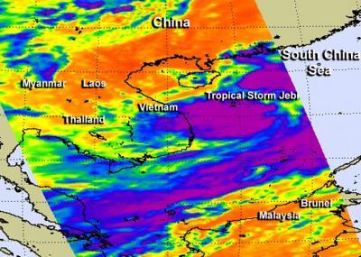
The AIRS instrument aboard NASA's Aqua satellite captured this infrared image of Tropical Storm Jebi on Aug. 1 at 6:11 a.m. EDT. Strongest storms and heaviest rains appear around southwest of the center where cloud top temperatures exceed -63F/-52C (purple).
(Photo Credit: NASA JPL/Ed Olsen)
The Joint Typhoon Warning Center noted that the low-level circulation center is consolidating as deep central convection is quickly developing.
At 1500 UTC/11 a.m. EDT on Aug. 1, Tropical Storm Jebi had maximum sustained winds near 40 knots/46 mph/74 kph. It was located near 17.0 north and 112.8 east, about 483 nautical miles east-southeast of Hanoi, Vietnam, but its cloud cover fills up a good deal of the South China Sea. Jebi is moving to the northwest at 7 knots/8 mph/13 kph.
The Joint Typhoon Warning Center expects Jebi to strengthen slightly before moving over Hainan Island, China, move through the Gulf of Tonkin, and make a final landfall over northern Vietnam within the next two days.
Source: NASA/Goddard Space Flight Center