Infrared imagery from NASA's Aqua satellite showed that Tropical Storm Kong-Rey's strongest thunderstorms were being pushed away from its center on its trek northward in the Western North Pacific Ocean.
As Tropical Storm Kong-Rey moved past the northern Philippines NASA's Aqua satellite captured an infrared image of the storm that revealed wind shear was taking a toll on the storm.
Tropical cyclones are made up of hundreds of thunderstorms, and the ones with the coldest cloud top temperatures shoot highest in the atmosphere and have a potential to drop heavy rain. The Atmospheric Infrared Sounder instrument that flies aboard NASA's Aqua satellite measured those cloud-top temperatures on Aug. 29 at 04:59 UTC when it flew over the storm from space. The strongest convection, coldest cloud top temperatures and heaviest thunderstorms had been pushed westward from the center as a result of moderate vertical wind shear. Moderate easterly wind shear pushed some of Kong-Rey's thunderstorms over eastern China as the storm's center continues to track over the ocean.
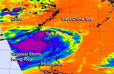
NASA's Aqua satellite captured this infrared image of Tropical Storm Kong-Rey on Aug. 29 at 04:59 UTC when it was just west of Taiwan and Luzon, Philippines.
(Photo Credit: Image : NASA/JPL, Ed Olsen)
By Aug. 29 at 1500 UTC/11 a.m. EDT, Kong-Rey had moved north of Taiwan. It was centered near 26.9 north and 122.4 east, about 100 nautical miles north-northeast of Taipei, Taiwan. Kong-Rey's maximum sustained winds were near 40 knots/46 mph/74 kph. The tropical storm was moving to the northwest at 4 knots/4.6 mph/7.4 kph, but is expected to turn to the northeast because of an approaching trough (elongated area) of low pressure moving in from the west. That trough will push Kong-Rey toward Japan.
Forecasters at the Joint Typhoon Warning Center or JTWC expect Kong-Rey to transition into a cold-core system and become extra-tropical within the next day. JTWC forecasters expect that Kong-Rey will make landfall in Japan sometime on Aug. 31 just south of Sasebo, Kyushu, Japan.
Source: NASA/Goddard Space Flight Center