NASA's Terra satellite passed over Typhoon Wutip on its approach to a landfall in Vietnam and a visible image revealed its 10-mile-wide eye, and large extent. Wutip was making landfall near Dong Hoi Vietnam around 0900 UTC/5 a.m. EDT.
On Sept. 30 at 03:35 UTC/Sept. 29 at 11:35 p.m. EDT, the Moderate Resolution Imaging Spectroradiometer or MODIS instrument that flies aboard NASA's Terra satellite took a visible image of Typhoon Wutip, clearly showing its eye. At that time, Wutip was still approaching landfall in Vietnam and the heaviest rainfall and strongest thunderstorms appeared on the western and southern sides of the storm. Thunderstorms in the northwestern quadrant of the storm appeared weaker as a result of moving over China's Hainan Island.
According to the International Business Times, officials in the coast areas of China's Quang Tri province evacuated more than 8,000 people. Vietnamese officials are planned to evacuate more than 140,000 people. IBT reported more than 75 people were missing from the storm.
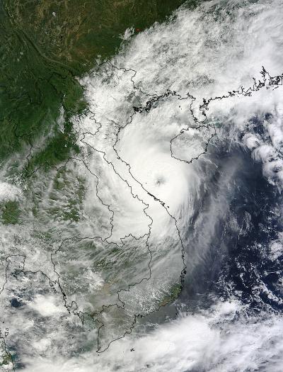
The image was taken by the MODIS instrument that flies aboard NASA's Terra satellite on Sept. 30 at 03:35 UTC. Wutip was approaching landfall in Vietnam.
(Photo Credit: : NASA MODIS Rapid Response Team)
On Monday, Sept. 30 at 0900 UTC/5 a.m. EDT, Wutip's center was near 17.6 north and 106.8 east, or 101 nautical miles north of Da Nang, (near Dong Hoi, Vietnam) as it began making landfall. Wutip was moving to the west-northwest near 10 knots/11.5 mph/18.5 kph, and had maximum sustained winds near 90 knots/103.6 mph/166.7 kph. Rainfall will stretch from China to Cambodia.
For updates and more information from Vietnam's National Centre for Hyrdop-meteorological Service, go to: http://www.nchmf.gov.vn/web/en-US/104/102/19028/Default.aspx.
Wutip's heavy rains are expected to cause flooding and landslides as it moves over Vietnam's central highlands and mountainous region. After landfall, Wutip is expected to dissipate over land in Vietnam and Laos within the next day or so because of the friction it will encounter from the rough terrain. Wutip is the tenth storm to impact Vietnam this year.
Source: NASA/Goddard Space Flight Center