When TRMM first passed over Jack, the storm had estimated sustained winds of 90 knots (103.6 mph/166.7 kph). The second time TRMM gathered data about Jack's rainfall, the storm's maximum sustained winds had dropped to 75 knots (86.3 mph/138.9 kph). Rainfall from TRMM's Microwave Imager (TMI) and Precipitation Radar (PR) were used to create images of rainfall rates. Rain was found by TRMM PR to be falling at a maximum rate of over 197 mm/hr. (7.8 inches) with the first pass and still falling at a rate of over 167 mm/hr. (6.6 inches) at the later time.
Although Jack was weakening on April 21, powerful thunderstorms tops were shown by TRMM PR to be reaching height of at least 17 km (10.5 miles) with both observations.
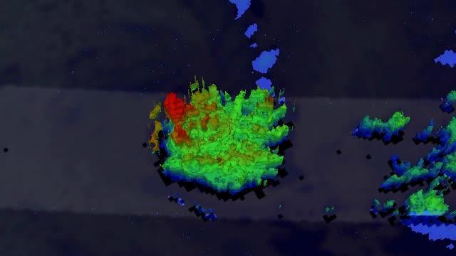
This 3-D flyby from NASA's TRMM satellite of Tropical Cyclone Jack on April 21 shows that some of the thunderstorms were shown by TRMM PR were still reaching height of at least 17 km (10.5 miles).
(Photo Credit: : NASA/SSAI, Hal Pierce)
By April 22 at 0900 UTC/5 a.m. EDT, Jack had weakened so much that it no longer qualified as a tropical cyclone. At that time Jack's maximum sustained winds were down to 30 knots (34.5 mph/55.5 kph). It was centered about 350 nautical miles (402.8 miles/648.2 km) southwest of Cocos Island, near 17.8 south latitude and 95.2 east longitude.
Strong vertical wind shear stretched out the low-level circulation center. Multi-spectral satellite data also showed the low-level center was interacting with an area of stratocumulus clouds to the south and it appears that dry air moving into the system, which will further weaken it.
Jack's remnants are expected to continue moving on a southeastward track over open waters, where they will meet their end.
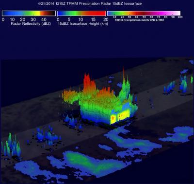
This 3-D image of Tropical Cyclone Jack shows that some of the thunderstorms were shown by TRMM PR were still reaching height of at least 17 km (10.5 miles) on April 21 at 12:154 UTC.
(Photo Credit: Image : NASA/SSAI, Hal Pierce)
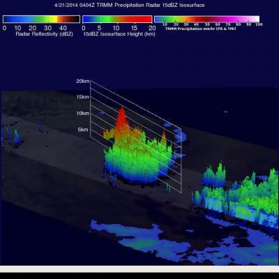
This 3-D image of Tropical Cyclone Jack shows that some of the thunderstorms were shown by TRMM PR to be reaching height of at least 17 km (10.5 miles) on April 21 at 4:04 UTC.
(Photo Credit: : NASA/SSAI, Hal Pierce)
Source: NASA/Goddard Space Flight Center