At 11 a.m. EDT (1500 UTC) the National Hurricane Center noted that the center of Tropical Storm Bertha was located near latitude 14.0 north and longitude 58.9 west, about 70 miles (110 km) southeast of Barbados. It was moving toward the west-northwest near 21 mph (33 kph) and that general motion is expected to continue for the next couple of days. NHC noted that Bertha is expected to move through the central Lesser Antilles during the night (August 1) and approach the Virgin Islands and Puerto Rico on Saturday, August 2. The estimated minimum central pressure is 1008 millibars.
The TRMM satellite, managed by both NASA and the Japan Aerospace Exploration Agency had an excellent view of tropical storm Bertha on August 1, 2014 at 0713 UTC (3:13 a.m. AST). Rainfall from TRMM's Microwave Imager (TMI) and Precipitation Radar (PR) revealed that rain was falling at a rate of over 109 mm (about 4.3 inches) per hour northeast of the sheared storm.
The National Hurricane Center noted Bertha is currently experiencing about 15-20 knots of southwesterly vertical wind shear which is pushing the heaviest rainfall northeast of the center. NHC also noted that water vapor imagery showed dry mid-/upper-level air near the storm. The forecast track calls for Bertha to interact with one or two upper-level troughs (elongated areas of low pressure) during the two to three days, which should cause some vertical wind shear and dry air to continue affecting the storm. Those are two factors that will limit the development and strengthening of the storm.
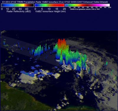
This 3-D flyby of Tropical Storm Bertha on Aug. 1 was created from TRMM satellite data. It shows (from the south) intense thunderstorms were reaching heights of over 15km (about 9.3 miles). TRMM showed rain was falling at a rate of over109 mm/4.3 inches (red) per hour northeast of the sheared storm.
(Photo Credit: Image : SSAI/NASA, Hal Pierce)
Radar reflectivity values from TRMM's Precipitation Radar (PR) instrument were used to create a 3-D view of the storm to show the structure of precipitation within Tropical Storm Bertha. The 3-D image showed that intense thunderstorms or "hot towers" were reaching heights of over 15km (about 9.3 miles). This kind of chimney cloud is called a "hot tower" because it releases a huge quantity of latent heat by condensation. The latent heat released in the center of tropical cyclones is usually an indicator of future intensification but vertical shear is expected to be a limiting factor for Bertha.
The NHC expects little change in Bertha's strength over the next two days.
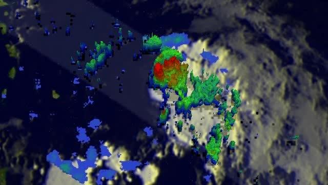
This 3-D view of Tropical Storm Bertha on Aug. 1 was created from TRMM satellite data. It shows (from the south) intense thunderstorms were reaching heights of over 15km (about 9.3 miles).
(Photo Credit: Image : SSAI/NASA, Hal Pierce)
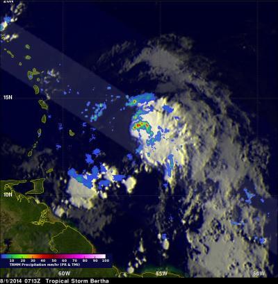
On Aug. 1, rainfall data from TRMM, combined with an infrared image from the GOES-East satellite showed rain was falling at a rate of over 109 mm/4.3 inches (red) per hour northeast of the sheared storm.
(Photo Credit: Image : SSAI/NASA, Hal Pierce)
Source: NASA/Goddard Space Flight Center