Infrared satellite imagery from shows how cold cloud top temperatures are in a tropical cyclone, and recent imagery from NASA's Aqua satellite shows the cloud-top temperatures have been warming in Tropical Storm 13W. Warming cloud top temperatures indicate less strength, and Tropical Storm 13W is weakening.
NASA's Aqua satellite passed over Tropical Storm 13W on August 7 at 0253 UTC. The Atmospheric Infrared Sounder (AIRS) instrument that flies onboard Aqua captured an infrared image of the storm's cloud temperatures that showed very limited strong thunderstorms make up the tropical cyclone and most of the precipitation was to the east of the center of circulation. The AIRS imagery also shows that the bands of thunderstorms around the center are fragmented.
On August 7 at 1500 UTC (11 a.m. EDT), Tropical Storm 13W's (TS13W) maximum sustained winds were near 35 knots (40.2 mph/64.8 kmh). TS13W was located 745 nautical miles (857 miles/1,380 km) north-northwest of Wake Island, near 30.2 North and 160.5 East. It was moving to the northwest near 9 knots (10.3 mph/16.6 kmh).
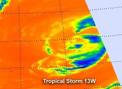
NASA's Aqua satellite passed over Tropical Storm 13W on Aug. 7 at 0253 UTC. The AIRS instrument captured an infrared image of the cloud temperatures that showed very limited strong storms (purple) and most of the precipitation was to the east of the center of circulation.
(Photo Credit: : NASA JPL, Ed Olsen)
The Joint Typhoon Warning Center forecasters noted that Tropical Storm 13W "Continues to maintain a warm core and will likely dissipate before transitioning to a subtropical or extra-tropical system."
Source: NASA/Goddard Space Flight Center