As cloud tops fall, their temperature rises, and infrared data from NASA's Aqua satellite saw that happening as Tropical Storm Gil weakened.
The Atmospheric Infrared Sounder or AIRS instrument captured an infrared picture of Tropical Storm Gil on Aug. 6 at 22:59 UTC (6:59 p.m. EDT). The AIRS data showed that cloud top temperatures had warmed since the day before, indicating that the thunderstorms that make up the tropical cyclone didn't have as much punch, or uplift to form more powerful storms. AIRS imagery is false-colored to show temperature and is created at NASA's Jet Propulsion Laboratory in Pasadena, Calif.
The last advisory on what is now Post-Tropical Cyclone Gil was issued on Aug. 7 at 0300 UTC (11 p.m. EDT on Aug. 6), by NOAA's Central Pacific Hurricane Center. At that time, Gil's maximum sustained winds were down to 30 knots. Gil was centered about 935 miles east-southeast of Hilo, Hawaii, near 13.5 north and 142.5 west. Gil was moving west-northwest at 6 knots.
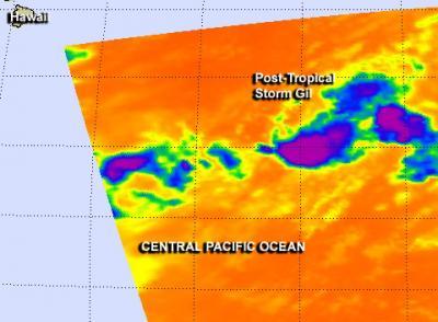
This Aug. 6 infrared image from AIRS on NASA's Aqua satellite showed that cloud top temperatures in Tropical Storm Gil were warming, a sign the storm was weakening.
(Photo Credit: NASA/JPL)
Gil has ceased to qualify as a tropical cyclone and its remnants are expected to continue moving in a westerly direction far south of Hawaii.
Source: NASA/Goddard Space Flight Center