The Global Precipitation Measurement (GPM) mission core satellite found moderate to heavy rainfall occurring in Tropical Depression Champi before it strengthened into a tropical storm.
Tropical Depression Twenty Five (TD25W) formed on Tuesday, October 13 east of Guam. The GPM core observatory satellite saw TD25W on October 13, 2015 at 1313 UTC (9:13 a.m. EDT) and found moderate to heavy rainfall falling at a rate of up to 67 mm (2.6 inches) per hour.
At NASA's Goddard Space Flight Center in Greenbelt, Maryland a 3-D image was made using GPM's Dual-Frequency Precipitation Radar (DPR) data where the Ku Band data sliced through the western side of the tropical depression.
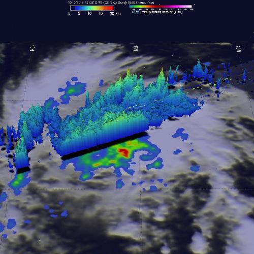 GPM core observatory satellite saw TD25W on Oct. 13, 2015, at 1313 UTC (9:13 a.m. EDT) and found moderate to heavy rainfall falling at a rate of up to 67 mm (2.6 inches) per hour. Credit: Credits: NASA/JAXA/SSAI, Hal Pierce
By October 14 at 0900 UTC (5 a.m. EDT), Tropical Depression 25W had strengthened into a tropical storm and was renamed Tropical Storm Champi. At that time, Champi was centered near 14.9 North latitude and 156.4 East longitude, about 614 nautical miles (706.6 miles/1,137 km) east of Saipan. Champi was moving to the west-northwest at 20 knots (23 mph/37 kph). Maximum sustained winds were near 35 knots (40 mph/64 kph).
The Joint Typhoon Warning Center forecast calls for Champi to move west-northwest and pass to the north of Guam. After passing Guam it is expected to peak in intensity near 110 knots (126.6 mph/203.7 kph) on October 18.
source: NASA/Goddard Space Flight Center