The next morning the sky was clear and the ocean was calm. Although my neighborhood didn't suffer much damage, other than a few electric wires falling, other areas of the island had fallen light poles, wires and trees, crushed fences and walls. Some homes had roofs that fell in or came completely off. I'm amazed at how many trees were uprooted or fallen over across the island."
By October 18, Gonzalo had moved north of Bermuda and was headed toward eastern Canada.
Between 7 a.m. and 8 a.m. on Oct. 19, a weather station on Cape Race, Newfoundland reported a sustained wind of 41 mph (67 kph) and a gust of 55 mph (89 kph). St. Johns Newfoundland recently reported a wind gust of 45 mph (72 kph).
At 8 a.m. EDT on Sunday, Oct. 19, Gonzalo was still a hurricane over the cold waters of the north Atlantic. A tropical storm watch is effect for Arnolds Cove to Chapels Cove, Newfoundland, Canada.
.On Sunday, Oct. 19 at 8 a.m. EDT, Gonzalo's center was near latitude 47.6 north and longitude 50.1 west. NOAA's GOES-East satellite captured a visible image of the storm on Sunday, Oct. 18 at 1145 UTC (7:45 a.m. EDT) that showed it in the North Atlantic, blanketing eastern Canada and stretching east over open waters. At that time, Gonzalo was moving toward the northeast near 52 mph (83 mph). Gonzalo moved quickly away from Newfoundland into the North Atlantic. Maximum sustained winds were near 85 mph (140 kph) and gradual weakening was forecast.
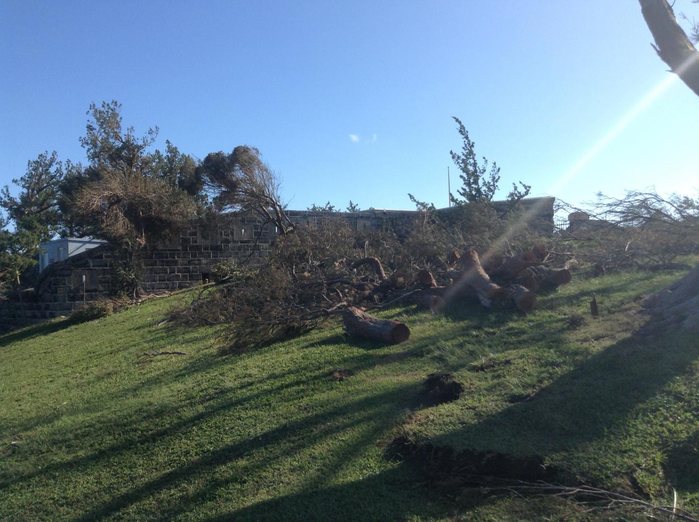
This image shows fallen trees littler the grounds at Fort Scaur, an historical landmark in Bermuda. Fort Scaur was built in 1870 and is located in Somerset, at the western end of Bermuda.
(Photo Credit: Camille Haley)
Just three hours later the MODIS instrument aboard NASA's Terra satellite captured a visible image that showed Hurricane Gonzalo had moved more than 150 miles further east from Newfoundland, Canada than when the GOES image was taken.
On Oct. 19 effects from Gonzalo were still being felt in many places because of dangerous ocean conditions. Large swells, now waning, were affecting the Virgin Islands, the northern coasts of Puerto Rico and the Dominican Republic, portions of the Bahamas, portions of the United States east coast, Bermuda and Atlantic Canada.
By Sunday night Gonzalo and become an extra-tropical cyclone with a cold core center (instead of a warm center like a tropical cyclone) as the National Hurricane Center expected.
Gonzalo is expected to affect Scotland on Tuesday, October 21 as an extra-tropical storm, packing heavy rains and gusty winds.
On Monday, Oct. 20, the U.K. Meteorological Service issued a National Severe Weather Warning for the U.K.: "The remains of Hurricane Gonzalo are running across the Atlantic, reaching the UK on Monday night, bringing a period of strong winds to the U.K. The strongest winds are expected on Tuesday as the low pressure clears eastwards; some uncertainty remains in peak windspeeds but there remains the potential for disruption to travel, especially as the strongest winds coincide with the morning rush hour in places. Fallen leaves impeding drainage increases the risk of surface water affecting roads, while some damage to trees is possible, given that many are still in full leaf." For updated warnings from the U.K. Met Service, visit: http://www.metoffice.gov.uk.
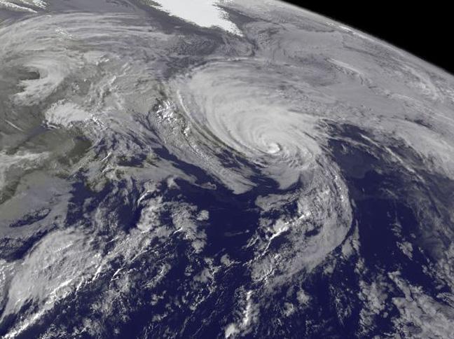
NOAA's GOES-East satellite captured a visible image of the storm on Sunday, Oct. 18 at 1145 UTC (7:45 a.m. EDT) that showed it in the North Atlantic, blanketing eastern Canada and stretching east over open waters.
(Photo Credit: NASA/NOAA GOES Project)
Source: NASA/Goddard Space Flight Center