Boulder, Colo., USA - In their article for Geosphere, R. Craig Kochel and colleagues discuss the geomorphic impact of the flooding caused Tropical Storm Lee in September 2011 on several large watersheds of the Susquehanna River in the Appalachian Plateau region of north-central Pennsylvania. Unlike many Appalachian floods, the physical impacts to channels and floodplains were extensive.
Channel widening (in places >100%) and bank erosion were common, and huge volumes of gravel were transported during the flood. Flood flows resulted in a significant threshold, crossing where channel patterns shifted from single-channel to multi-thread along many reaches.
Kochel and colleagues suggest that part of the reason for such extensive changes from the flood were related to the land-use history of these watersheds. Watershed-scale deforestation occurred in these streams between 1850 and 1920, resulting in hillslope erosion and downstream floodplain sedimentation. In addition, the former multi-thread gravel-bed channel system was altered by the construction of berms, narrowing the active part of the streams to a single channel.
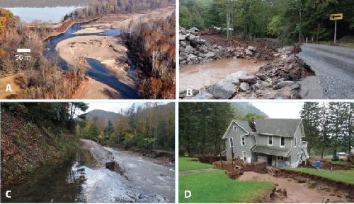 Examples of erosion and deposition in north-central Pennsylvania from Tropical Storm Lee. (A) Extensive gravel bars formed in a disequilibrium zone on lower Fishing Creek. (B) Washed out bridge in upper Muncy Creek. (C) Eroded road along Big Bear Creek, upper Loyalsock Creek watershed. (D) House eroded on a Pleistocene terrace, Loyalsock Creek. Credit: R. Craig Kochel et al. and Geosphere.
After the logging era, infrastructure (including homes, highways, and farms) was established on the floodplain that was protected by the berms. The 2011 flood breached these berms, aggraded channels with gravel bars to floodplain elevations, and resulted in numerous avulsions and chutes eroded through the insides of meander bends. These changes reconnected the modified single-channel system with its preexisting multi-thread channel system and resulted in extensive damage to highways, bridges, farms, homes, and other infrastructure in the region.
The increased coarse gravel load available to channels is causing rivers to adjust their morphology and return to multi-thread systems where flood flows occupy numerous channels across valley-wide floodplains. Understanding the trajectory of the geomorphic adjustment of streams in this region is critical to making wise management and land-use policy decisions. Watershed managers would find prudence in evaluating fluvial systems on a watershed scale that addresses adjustments in sediment load and discharge produced by natural changes as well as historical land-use practices.
FEATURED ARTICLEGeomorphic response to catastrophic flooding in north-central Pennsylvania from Tropical Storm Lee (September 2011): Intersection of fluvial disequilibrium and the legacy of loggingR. Craig Kochel et al., Dept. of Geology & Environmental Geosciences, Bucknell University, 1 Dent Drive, Lewisburg, Pennsylvania 17837, USA. This article is online at http://dx.doi.org/10.1130/GES01180.1.
Other GEOSPHERE articles (see below) cover such topics as
Geothermal gradients of the northern continental shelf of the Gulf of MexicoCory H. Christie and Seiichi Nagihara, Dept. of Geosciences, Texas Tech University, Box 41053, Lubbock, Texas 79409, USA. This article is online at http://dx.doi.org/10.1130/GES01163.1. Themed issue: Geothermal Energy from Sedimentary Basins: Challenges, Potential, and Ways Forward.
Previous studies have observed regional variation in geothermal gradients in the northern continental shelf of the Gulf of Mexico. This study characterizes the geographic variation trends in more detail by utilizing the new database compiled for the National Geothermal Data System. This study also examines the possible cause of the variation by building computer simulation models for the heat transfer through the crust and the sediment of the continental shelf. The authors conclude that the variation can be explained primarily by two competing thermal effects of sediment accumulation. The first is that rapid sediment accumulation taking place there reduces the upward heat transport through the sedimentary column of the continental shelf. The second is that the heat produced by radioactive decays of uranium, thorium, and potassium contained in the sediments adds to the heat budget. Where the first effect prevails, geothermal gradients are lower. Where the second effect prevails, geothermal gradients are higher.
Hidden intrabasin extension: Evidence for dike-fault interaction from magnetic, gravity, and seismic reflection data in Surprise Valley, northeastern CaliforniaNoah D. Athens et al., U.S. Geological Survey, 345 Middlefield Road, Menlo Park, California 94025, USA. This article is online at http://dx.doi.org/10.1130/GES01173.1. Themed issue: Anatomy of Rifting: Tectonics and Magmatism in Continental Rifts, Oceanic Spreading Centers, and Transforms.
The North American plate is being stretched in the Basin and Range province, which spans eastern California, Nevada, and western Utah. For over a century, scientists have recognized the large earthquake faults -- spaced about 20 to 30 miles apart -- that separate each basin from its adjacent range. Now a team of researchers from Stanford University, Central Washington University, and the USGS has identified new evidence for stretching beneath the surface. Using geophysical techniques to probe beneath the sediments in Surprise Valley, northeastern California, the team identified a dike of frozen magma that was intruded into a fault located within the center of the valley. These results suggest that the Surprise Valley basin was (1) stretched quite a bit more than previously thought, (2) that some of this stretching was taken up by igneous intrusion rather than faulting alone, and (3) that both the magmatic activity and the faulting continued into the recent geological past. This research is significant in that it implies that both the total extension and magmatic component of rift basins may have also been underestimated in other parts of the world.
Robust best-fit planes from geospatial dataRichard R. Jones et al., Geospatial Research Ltd., Dept. of Earth Sciences, University of Durham, Durham DH1 3LE, UK. This article is online at http://dx.doi.org/10.1130/GES01247.1.
Modern survey technologies, including laser-based scanning, are now routinely used to record detailed, high precision 3D images of areas of geological interest. The resultant "virtual outcrops" can then be visualized and analyzed quantitatively by geologists back in the lab. A major research effort currently underway is to improve the characterization of fracture systems that control the flow of water, oil & gas, and mineralized fluids through the rock. Since this analysis can involve many thousands of individual fractures, we need a robust method to identify whether the measurement of each fracture plane is statistically valid. It turns out that the underlying math to achieve this was initially developed in the 19th century, and a solution was formulated over one hundred years ago.
Depositional paleoenvironment and hydrocarbon source potential of the Oligocene Dabaa Formation, north Western Desert, Egypt: A palynofacies approachSalah Y. El Beialy et al., Geology Dept., Faculty of Science, Mansoura University, Mansoura, Dakahlia 35516, Egypt; and Dept. of Geosciences and Geological and Petroleum Engineering, Missouri University of Science and Technology, 129 McNutt Hall, 1400 N. Bishop, Rolla, Missouri 65409, USA. This article is online at http://dx.doi.org/10.1130/GES01227.1.
This research focuses on subsurface rocks formed during the Oligocene (~23 to 34 million years ago) in the north Western Desert of Egypt. The preserved fossil organic matter in these sedimentary rocks were extracted and described in order to provide information about (1) the different environmental conditions prevailed during their deposition and accumulation, and (2) the potential of their containing rocks as hydrocarbon sources. The authors found that the rocks deposited in a marine environment that experienced changes in sea level as well as oxidation-reduction conditions. These rocks also contained horizons of organic matter that expected to produce both oil and gas at thermal maturation. However, these rocks were found thermally immature, meaning that they were not heated enough for the hydrocarbons to expel. A new ternary plot was proposed to represent the different types of sedimentary organic matter as paleoenvironmental indicators.
Using geophysical techniques to trace active faults in the urbanized northern Hueco Bolson, West Texas, USA, and northern Chihuahua, MexicoVictor M. Avila et al., Dept. of Geological Sciences, University of Texas at El Paso, El Paso, Texas 79968, USA. This article is online at http://dx.doi.org/10.1130/GES01228.1.
We have used a combination of measurements of Earth's gravity field and water well information to map the locations of concealed faults beneath the heavily urbanized Hueco Bolson portion of the El Paso-Ciudad Juárez metropolitan area and estimate depth to bedrock. Our results suggest the East Franklin Mountains fault, a fault that has shown repeated movement in earthquakes over the past 64,000 years, extends 20 to 30 km south of the end of its mapped surface trace (near the U.S. border) into Mexico. We have traced at least three other concealed faults from the U.S. into Mexico. Between 1800 and 2500 m of sediment fills the irregularly shaped basin and would likely enhance strong ground motion in the most heavily urbanized areas of the two cities during earthquakes.
Geology of the High Rock caldera complex, northwest Nevada, and implications for intense rhyolitic volcanism associated with flood basalt magmatism and the initiation of the Snake River Plain-Yellowstone trendMatthew A. Coble and Gail A. Mahood, Dept. of Geological Sciences, Stanford University, 450 Serra Mall, Stanford, California 94305-2115, USA. This article is online at http://dx.doi.org/10.1130/GES01162.1. Themed issue: Cenozoic Tectonics, Magmatism, and Stratigraphy of the Snake River Plain-Yellowstone Region and Adjacent Areas.
We present the geologic history of the High Rock Caldera Complex, a major mid-Miocene silicic center in northwestern Nevada and southern Oregon. Volcanism was concentrated during a ~1 million-year interval between 16.4 and 15.5 Ma contemporaneous with eruption of flood basalts across the region. Together with compositionally similar rhyolites from nearby centers, the High Rock Caldera Complex redefines the starting point for the eastward-younging trend of voluminous rhyolitic calderas of the Snake River Plain/Yellowstone trend. We propose that caldera complex centers are localized where flood basalts encountered transitional crust west of the craton with a composition and thickness that allowed significant partial melting. The overall volumetric eruptive rates of widespread mid-Miocene silicic volcanism associated with Steens/Columbia River flood basalts are similar to the range of other flood-basalt-related silicic provinces globally (2,500-12,000 km3/my), which is consistent with the short-lived, intense volcanism interpreted as being related to arrival of a mantle plume beneath continental lithosphere.
TerraceM: A MATLAB® tool to analyze marine and lacustrine terraces using high-resolution topographyJulius Jara-Muñoz et al., Institut für Erd- und Umweltwissenschaften, Universität Potsdam, 14476 Potsdam-Golm, Germany. This article is online at http://dx.doi.org/10.1130/GES01208.1.
We present TerraceM, a user-friendly GUI programed in MATLAB(R) to analyze marine and lacustrine terraces using high resolution topography. TerraceM uses several tools to obtain accurate measurements of the shoreline angle, a geomorphic feature that can be correlated with past sea-levels positions. TerraceM enable processing series of swath profiles from several sites in an efficient and structured workflow. We believe that TerraceM will help to expand and facilitate regional studies of marine and lacustrine terraces.
Structural reconstruction and age of an extensionally faulted porphyry molybdenum system at Spruce Mountain, Elko County, NevadaJames R. Pape et al., Lowell Institute for Mineral Resources, Dept. of Geosciences, University of Arizona, 1040 East Fourth Street, Tucson, Arizona 85721-0077, USA. This article is online at http://dx.doi.org/10.1130/GES01249.1.
This study by James R. Pape and colleagues documents the ages and magnitudes of multiple overprinted phases of extensional faulting at Spruce Mountain, a historic mining district in northeastern Nevada (USA). They also age-date, classify, and reconstruct a molybdenum ore deposit that was deformed by the youngest phases of faulting. Notably, they find that the earliest and most substantial phases of extensional faulting at Spruce Mountain occurred before the formation of the ore deposit at 38 Ma. This is significant because previous studies in northeastern Nevada have argued that the magnitude of extensional faulting in the region was relatively minor prior to 17 Ma. In contrast, these findings at Spruce Mountain suggest that early phases of extension (before 17 Ma) were at least locally important as well.
source: Geological Society of America