Forest fires are burning north and east of Russia's Irkutsk Oblast. The Irkutsk Oblast is located in southeastern Siberia in the basins of Angara, Lena, and Nizhnyaya Tunguska Rivers.
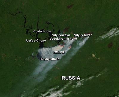
NASA's Aqua satellite passed over the area and captured an image showing multiple forest fires and smoke plumes. Some of the places affected by the smoke include Cokhchuolu, Ust'ye-Chony, Skysykatakh, and Chernyshevskiy along the Vilyuy River. These appear to be recreational areas.
South of the Vilyuy River is the town of Mirny. It is known for having the world's largest diamond mine.
Forest fires are burning north and east of Russia's Irkutsk Oblast. The Irkutsk Oblast is located in southeastern Siberia in the basins of Angara, Lena, and Nizhnyaya Tunguska Rivers.
(Photo Credit: Image: Jeff Schmaltz, NASA Goddard MODIS Rapid Response Team; Caption: Rob Gutro, NASA Goddard Space Flight Center)
The Moderate Resolution Imaging Spectroradiometer (MODIS) instrument aboard NASA's Aqua satellite has infrared capabilities that can detect heat from the various wildfires. This image was captured on July 22, 2013 at 05:50 UTC (1:50 a.m. EDT). In the MODIS image the fire or hot spot appears red and smoke appears in light brown. Images are generated at NASA's Goddard Space Flight Center in Greenbelt, Md.
Source: NASA/Goddard Space Flight Center