Boulder, Colo. - The hazard posed by large earthquakes is difficult to estimate because they often occur hundreds to thousands of years apart. Because written records for the Puget Lowland of northwestern Washington cover less than 170 years, the size and frequency of the largest and oldest earthquakes on the Seattle and Tacoma faults are unknown. Past earthquakes can only be estimated through geologic studies of sediments and landforms that are created when faults break the ground surface.
Along the Cascadia margin, the cities of Seattle and Tacoma occupy the Puget Lowland, a structurally complex, seismically active forearc trough between the Coast Range and the Cascade volcanic arc. Deformation of the lowland is caused by the clockwise motion of western Oregon, pushing northward and compressing western Washington against slower moving Canada. Much of the north- to northeast-directed strain in the southern Puget Lowland is accommodated by deformation in the Seattle fault zone, the Tacoma fault zone, the Saddle Mountain deformation zone, and along the Olympia fault.
In their paper for Geosphere, published online 25 June 2014, Alan R. Nelson and colleagues write that although in 1992 a very large earthquake on the Seattle fault was dated to a thousand years ago, the size and frequency of earlier earthquakes on active faults of the southern Puget Lowland remains uncertain. Through a synthesis of earlier geologic data with new field evidence of earthquake faulting at nine sites on the Seattle and Tacoma faults, Nelson and colleagues show that four or five earthquakes large enough to break the ground surface occurred on the Seattle fault or related faults during the past 3,500 years.
FEATURED ARTICLEDiverse rupture modes for surface-deforming upper plate earthquakes in the southern Puget Lowland of Washington StateAlan R. Nelson et al., Geologic Hazards Science Center, U.S. Geological Survey, MS 966, PO Box 25046, Denver, Colorado 80225, USA. Published online 25 June 2014; http://dx.doi.org/10.1130/GES00967.1.
Other Geosphere articles cover such topics as1.
- Stream and karst piracy
- The 4 April 2010 Mayor-Cucapah earthquake, Baja California, Mexico
- Snail fossils in the Tertiary Grand Canyon
All Geosphere articles available at http://geosphere.gsapubs.org/.
Representatives of the media may obtain complimentary copies of Geosphere articles by contacting Kea Giles at the address above. Please discuss articles of interest with the authors before publishing stories on their work, and please make reference to Geosphere in articles published.
Non-media requests for articles may be directed to GSA Sales and Service, gsaservice@geosociety.org.
Abandonment of Unaweep Canyon (1.4-0.8 Ma), western Colorado: Effects of stream capture and anomalously rapid Pleistocene river incisionAndres Aslan et al., Dept. of Physical and Environmental Sciences, Colorado Mesa University, Grand Junction, Colorado 81501, USA. Published online 13 May 2014; http://dx.doi.org/10.1130/GES00986.1. Special series: CRevolution 2: Origin and Evolution of the Colorado River System II.
Unaweep Canyon is the most spectacular example of stream piracy resulting in canyon abandonment in the upper Colorado River system. New age estimates show that canyon abandonment took place between 0.8 and 1.4 million years ago. It is also clear that abandonment was not triggered by regional uplift of the Uncompahgre Plateau. Capture of the ancestral Gunnison River by the ancestral Colorado River produced a wave of river incision upstream along the Gunnison and Uncompahgre River systems resulting in at least one additional stream capture event. Stream piracy effects must be evaluated carefully in order to formulate accurate interpretations of landscape evolution.
Aftermath of a stream capture: Cactus Park lake spillover and the origin of East Creek, Uncompahgre Plateau, western ColoradoWilliam C. Hood et al., Grand Junction Geological Society, 515 Dove Court, Grand Junction, Colorado 81507, USA. Published online 13 May 2014; http://dx.doi.org/10.1130/GES00970.1. Special series: CRevolution 2: Origin and Evolution of the Colorado River System II.
This paper describes how an ancient lake formed high on the flanks of the Uncompahgre Plateau in western Colorado. The lake formed in Cactus Park, a tributary valley to Unaweep Canyon and existed about 800,000 years ago. Overflow from this lake led to the development of East Creek and deflected the Gunnison River eastward. These long-ago events have exerted a strong influence on the modern landscape.
Karst piracy: A mechanism for integrating the Colorado River across the Kaibab uplift, Grand Canyon, Arizona, USACarol A. Hill and Victor J. Polyak, Earth and Planetary Sciences, University of New Mexico, 200 Yale Boulevard, Albuquerque, New Mexico 87131, USA. Published online 25 June 2014; http://dx.doi.org/10.1130/GES00940.1. Special series: Crevolution 2: Origin and Evolution of the Colorado River System II.
In this paper, a karst piracy mechanism is proposed to explain how the Colorado River crossed the Kaibab uplift topographic high: it went under the uplift, thus hydrologically connecting the east side of the canyon with the west side. A karst connection at five to six million years ago not only caused the headward erosion of Marble Canyon (and thus its age of 5 to 6 million years), but also headward erosion up Little Colorado River Canyon at this time. Karst piracy also favors five to six million years as the time of integration of the Colorado River across the entire Grand Canyon, where the river followed the route of a much earlier (Late Cretaceous to Miocene) paleocanyon west of the Kaibab uplift.
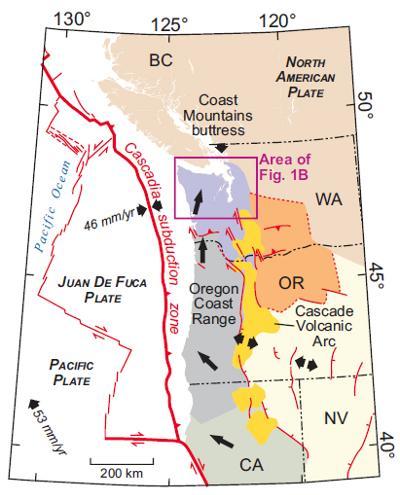
This is figure 1A from Nelson et al., 'Kinematic model of the Cascadia forearc.' Northward migration of the Oregon Coast Range squeezes western Washington against the North American plate, producing faults and earthquakes in the Puget Lowland. Red lines are faults; black arrows show motions of tectonic blocks.
(Photo Credit: Geosphere and A.R. Nelson et al.)
Assembly of a large earthquake from a complex fault system: Surface rupture kinematics of the 4 April 2010 El Mayor-Cucapah (Mexico) Mw 7.2 earthquakeJohn M. Fletcher et al., Departamento de Geologia, Centro de Investigacion Cientifica y de Educacion Superior de Ensenada, Carratera Tijuana-Ensenada No. 3918, Zona Playitas, Ensenada, Baja California, C.P. 22860, México. Published online 25 June 2014; http://dx.doi.org/10.1130/GES00933.1.
In this paper, John M. Fletcher and colleagues document the styles of ground failure and faulting associated with the 4 April 2010 Mw 7.2 Mayor-Cucapah earthquake, which was the largest earthquake to strike northern Baja California, Mexico in more than 100 years. This earthquake was special in many ways. It produced a rupture 120 km long on a fault system that was not previously known to exist. The fault system is complex and composed of at least seven individual faults with distinct orientations and senses of slip. One of the faults is inclined at a very shallow angle (as low as 20 degrees) and is an example of a class of faults that is very controversial. The controversy centers on the fact that they violate basic theories of faulting for regions where the crust is being extended, which is the case for the northern Gulf of California. Additionally, slip on such faults is extremely rare in the historical seismic record. Thus this earthquake provides a unique opportunity to understand this controversial class of faults as well as to add to our knowledge of how earthquake ruptures pass through a complex network, cascading from one fault to another.
Paleogene Grand Canyon incompatible with Tertiary paleogeography and stratigraphyRichard A. Young and Ryan Crow, Dept. of Geological Sciences, State University of New York, 1 College Circle, Geneseo, New York 14454, USA; Dept. of Earth & Planetary Sciences, University of New Mexico, MSC03-2040, Albuquerque, New Mexico 87131, USA. Published online 25 June 2014; http://dx.doi.org/10.1130/GES00973.1. Special series: Crevolution 2: Origin and Evolution of the Colorado River System II.
The western Grand Canyon region on the Hualapai Plateau in Arizona contains an unusually long sedimentary record of the local geologic history extending back at least 50 million years. The evidence is contained in a series of abandoned canyons, associated river gravels, and lava flows that existed prior to the modern Grand Canyon. The older rivers flowed toward the northeast in the opposite direction from the modern Colorado River. The early Tertiary age of the old river sediments has been confirmed by radiometric dates acquired on a recently discovered volcanic ash layer, as well as by the presence of gastropod (snail) fossils that lived in isolated lake basins created by damming of the old rivers during folding and faulting of the bedrock. The field research that documents the geologic history of this region fills in a lengthy gap in the controversial and incomplete history leading up to the formation of the western Grand Canyon. The location and distribution of the sediments deposited prior to the erosion of the younger Grand Canyon also demonstrate that there is no space or evidence for an ancestral Grand Canyon existing more than 50 million years ago, as has recently been proposed by other geologists. The improved geologic time constraints clearly support the prevailing evidence that the Grand Canyon was eroded to its present dimensions mostly within the last 5 to 6 million years. A companion paper (still in press) by R.A. Young and J.H. Hartman describes the paleontologic evidence for the age and distribution of the oldest river sediments across the broader region.
Bouse Formation in the Bristol basin near Amboy, California, USADavid M. Miller et al., U.S. Geological Survey, 345 Middlefield Road, Menlo Park, California 94025, USA. Published online 13 May 2014; http://dx.doi.org/10.1130/GES00934.1. Special series: CRevolution 2: Origin and Evolution of the Colorado River System II.
The Bouse Formation in the lower Colorado River area has intrigued geologists for over a century because it has many enigmatic fossils and deposits that are hard to unambiguously ascribe to either lake or estuary origin. This paper describes similar rocks far to the west in an isolated basin of the Mojave Desert, near Amboy, California, USA. The Amboy deposits consist of limestone similar to that near the Colorado River and contain the same volcanic ash deposit, making it the same age. On these bases, it is considered to be the Bouse Formation. By virtue of its isolated position far from the original water source, it may offer contrasts with the main Bouse outcrops that provide insight into lake or estuary origin. Fossils at Amboy reported in this paper differ in some respects from those at the Colorado River but do not by themselves resolve the origin of the Bouse Formation.
Structural overprinting of Mesozoic thrust systems in eastern California and its importance to reconstruction of Neogene extension in the southern Basin and RangeTerry L. Pavlis et al., Dept. of Geological Sciences, University of Texas at El Paso, El Paso, Texas 79968, USA. Published online 25 June 2014; http://dx.doi.org/10.1130/GES00993.1.
From the abstract: Geologic observations from the Resting Spring and Nopah Ranges (California, USA) together with a synthesis of regional data indicate that previous reconstructions of the Death Valley extensional terrane need to be revised because they do not account for three-dimensional, pre-extensional structures that complicate structural markers used in these reconstructions. This conclusion arises from detailed mapping that indicates structural overprinting of early northeast-trending fold-thrust systems of the Sevier orogenic belt by younger northwest-trending structures. The Resting Spring-Nopah-Spring Mountains restoration provides a template for future restorations. We emphasize that the three-dimensional pre-extensional geometry, together with other markers like Mesozoic magmatic belts and older sedimentary facies trends, provides an opportunity for using modern visualization and database systems to develop high-precision reconstructions using the abundance of crosscutting markers. Thus, although this study, along with other recent studies, indicates that previous reconstructions are not workable, future studies that include the full three-dimensional data could lead to a nearly unique solution to the pre-extensional paleogeography.
Tsunami-generated sediment wave channels at Lake Tahoe, California-Nevada, USAJames G. Moore et al., U.S. Geological Survey, 345 Middlefield Road, Menlo Park, California 94025, USA. Published online 25 June 2014; http://dx.doi.org/10.1130/GES01025.1.
A detailed 1999 USGS sonar map of Lake Tahoe first revealed a giant landslide from the west wall of the lake basin that crossed the lake. The 2.5 cubic mile landslide is the second largest on the continent in the last 2 million years, exceeded only in size by a landslide on the north side of Mt. Shasta. The slide occurred between 12,000 and 21,000 years ago. The sonar mapping also revealed that 15 major subaqueous channel systems ring the lake and each extend several miles from near the shore to the flat lake bottom 1600 feet deep. These systems all contain giant ripple marks up to 400 yards from crest to crest. Such bedforms are common in submarine canyons where they are called sediment waves. The Tahoe sediment wave channel systems were fed by sheets of water up to two miles wide. They narrow downslope to an incised channel, which than terminates in a broad apron on the flat lake floor. These channels resemble recently mapped sediment wave channels that are forming where the Squamish River in British Columbia enters the ocean. Sediment in the river is deposited at the coast forming a delta, which becomes unstable, collapses, and feeds the sediment wave channels. All the Tahoe sediment wave channels formed at the same time as the landslide and were fed by the backwash from major tsunamis caused by water splashed out of the lake. The backwash of these tsunamis was equivalent to 15 major rivers flowing across the shoreline and would have decimated life in the lower Tahoe Basin.
Late Miocene erosion and evolution of topography along the western slope of the Colorado RockiesRussell Rosenberg et al., Penn State University, Dept. of Geosciences, University Park, Pennsylvania 16802, USA. Published online 14 July 2014; http://dx.doi.org/10.1130/GES00989.1. Special series: Crevolution 2: Origin and Evolution of the Colorado River System II.
From the abstract: In the Colorado Rocky Mountains, the association of high topography and low seismic velocity in the underlying mantle suggests that recent changes in lithospheric buoyancy may have been associated with surface uplift of the range. This paper examines the relationships among late Cenozoic fluvial incision, channel steepness, and mantle velocity domains along the western slope of the northern Colorado Rockies. New 40Ar/39Ar ages on basalts capping the Tertiary Browns Park Formation range at about six to 11 million years old (Ma) and provide markers from which we reconstruct incision along the White, Yampa, and Little Snake rivers. The magnitude of post-10 Ma incision varies systematically from north to south, increasing from ∼500 m along the Little Snake River to ∼1500 m along the Colorado River. Spatial variations in the amount of late Cenozoic incision are matched by metrics of channel steepness; the upper Colorado River and its tributaries (e.g., Gunnison and Dolores rivers) are two to three times steeper than the Yampa and White rivers, and these variations are independent of both discharge and lithologic substrate. The coincidence of steep river profiles with deep incision suggests that the fluvial systems are dynamically adjusting to an external forcing but is not readily explained by a putative increase in erosivity associated with late Cenozoic climate change. Rather, channel steepness correlates with the position of the channels relative to low-velocity mantle. We suggest that the history of late Miocene-present incision and channel adjustment reflects long-wavelength tilting across the western slope of the Rocky Mountains.
Dynamic response to strike-slip tectonic control on the deposition and evolution of the Baranof Fan, Gulf of AlaskaMaureen A.L. Walton, et al., Institute for Geophysics, Jackson School of Geosciences, The University of Texas at Austin, J.J. Pickle Research Campus Building 196, 10100 Burnet Road, Austin, Texas 78758-4445, USA. Published online 14 July 2014; http://dx.doi.org/10.1130/GES001034.1. Special series: Exploring the Deep Sea and Beyond, Volume 2.
The Baranof Fan is one of three deep-sea sedimentary fans in the Gulf of Alaska, and a key component in understanding regional sedimentation processes offshore of southeast Alaska and western Canada. Recently-collected seismic reflection data over the fan area provide new constraints on fan size, volume, channel development, and tectonic influences on deposition. We find the area and total sediment volume of the Baranof Fan to be 323,000 square kilometers and 301,000 cubic kilometers, respectively, making the Baranof Fan roughly the size of the Mississippi Fan and therefore among the largest deep-sea fans in the world. Three channel systems, including the newly mapped Baranof channel system, consistently decrease in age moving southward within the fan. Because the Baranof Fan is located along the Queen Charlotte strike-slip fault, we interpret that this southward-younging pattern of channel-levee deposits is due to the changing position of the Pacific plate relative to sediment sources on the North America plate through time. A tectonic model of fan development indicates that organized fan deposition may have initiated around seven million years ago.
Geologic history of Siletzia, a large igneous province in the Oregon and Washington Coast Range: Correlation to the geomagnetic polarity time scale and implications for a long-lived Yellowstone hotspotRay Wells et al., U.S. Geological Survey, 345 Middlefield Road, Menlo Park, California 94025-3561, USA. Published online 14 July 2014; http://dx.doi.org/10.1130/GES001018.1.
Along Oregon and Washington's Cascadia subduction zone, the leading edge of North America consists of a voluminous oceanic basalt terrane similar to the Hawaiian Islands that collided with the continent about 50 million years ago. Ray Wells and colleagues document the eruptive and kinematic history of the accreted oceanic basalt basement (Siletzia) and a similar, sister Yakutat terrane in Alaska. They correlate new Siletzia isotopic ages, nannofossil zones and magnetic polarities to the 2012 global timescale and construct a plate motion model for the northeast Pacific basin. Wells and colleagues demonstrate a common origin for the terranes at the Yellowstone hotspot offshore, their rapid accretion to the continent, and magmatic rejuvenation of Siletzia as the leading edge of North America overrode the hotspot 42 million years ago. Subsequent large-scale clockwise rotation of the Pacific Northwest has rotated Siletzia about 250 km northward off the hotspot track.
Graphite reaction weakening of fault rocks, and uplift of the Annapurna Himal, central NepalD. Craw and P. Upton, Geology Dept., University of Otago, PO Box 56, Dunedin 9054, New Zealand, and GNS Science, PO Box 30368, Lower Hutt 5040, New Zealand. Published online 14 July 2014; http://dx.doi.org/10.1130/GES001056.1.
This article shows that chemical processes in fault zones can lead to deposition of the carbon mineral graphite, which is a lubricant. Graphite-rich fault rocks can focus and enhance the sliding processes of rocks during earthquakes. Our example of a fault in the Himalaya has assisted in uplift of one of the world's highest mountains, Annapurna. Uplift movement on the graphite-lubricated fault has resulted in an extremely steep topographic step on the north side of the mountain. Graphite accumulation in the fault has also limited the natural discharge of greenhouse gases to the atmosphere.
Source: Geological Society of America