Shortly after dawn broke in the Eastern Pacific Ocean this morning, May 23, Tropical Depression 1E organized and strengthened into the first tropical storm of the season: Amanda
NOAA's GOES-West satellite provided a visible image of Amanda on May 23 at 1500 UTC (11 a.m. EDT/8 a.m. PDT). The GOES imagery showed strong thunderstorms in the northern and western quadrants and is indicative of a better structure in the banding of thunderstorms around the low-level center of circulation.
By that time, Amanda's maximum sustained winds had increased to 40 mph (65 kph). Tropical-storm-force winds extend outward up to 35 miles (55 km) from the center. The NHC discussion indicated that forecasters there expect Amanda to reach hurricane strength in about three or so days.
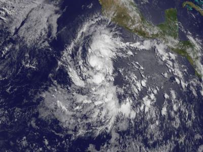
NOAA's GOES-West satellite captured this visible image of renamed Tropical Storm Amanda on May 23 at 1500 UTC/11 a.m. EDT.
(Photo Credit: Image : NASA/NOAA GOES Project)
Amanda was centered near 10.9 north latitude and 108.4 west longitude, about 620 miles (1,000 km) south-southwest of Manzanillo, Mexico. Amanda was moving to the west-northwest at 5 mph (7 kph) and had a minimum central pressure of 1005 millibars.
Forecaster Berg at the National Hurricane Center noted that Amanda is expected to remain in weak steering flow (which means there's not a strong weather system to push or guide it), and its motion should remain less than 5 knots during the next 5 days.
Source: NASA/Goddard Space Flight Center