Boulder, Colo., USA - In the August 2014 issue of LITHOSPHERE, Steve Israel of the Yukon Geological Survey and colleagues provide conclusions regarding the North American Cordillera that they say "are provocative in that they blur the definition of tectonic terranes, showing that many observations of early geologists can be attributed to evolving geologic processes rather than disparate geologic histories."
Western North America is characterized by the Cordilleran accretionary mountain belt, which has seen episodic plate convergence since the early Paleozoic, about 253 million years ago. Israel and colleagues write that this long-lived accretionary history of the northern Cordillera has resulted in a "collage of terranes" and overlap assemblages that seemingly have quite disparate geologic histories.
Early geologic research in the North American Cordillera identified several tectonic terranes that were considered to be fundamentally different from one another based upon lithologic and age characteristics. Many of these terranes were thought to have traveled great distances before separately accreting to the ancient North American margin.
Two of the largest terranes, the Alexander terrane and Wrangellia, found along western British Columbia, southwest Yukon, and eastern Alaska, have long been considered to be exotic to each other and to North America. However, in their investigation of relationship between Wrangellia and the Alexander terrane, Israel and colleagues have found evidence that suggests that the two terranes have shared a history since the Latest Devonian (about 364 million years ago), and that portions of Wrangellia are built upon a basement composed of the Alexander terrane.
Israel and colleagues note that this conclusion would see the collage transformed into a more coherent picture with geologic ties between terranes that were previously thought of as complete separate entities. They conclude that this view of terranes adheres to the more traditional ideas of possible links between Laurentia and the accreted terranes with a few seemingly truly exotic pieces caught up in the collage.
FEATURED ARTICLE
New ties between the Alexander terrane and Wrangellia and implications for North America Cordilleran evolutionSteve Israel et al., Yukon Geological Survey, P.O. Box 2703(K-14), Whitehorse, Yukon, Y1A 2C6, Canada. August 2014 issue; online at http://dx.doi.org/10.1130/L364.1.
This and other articles in this issue were first posted online in May 2014:
1. Two related papers investigate topography, erosion, and climate in the Bolivian Andes;
2. A geochronologic analysis of the formation of the Sierra Norte de Córdoba and Pampean evolution in Argentina; and
3. Dating of rocks at Ama Drime, Tibet, to further understand the early evolution of the Himalaya.
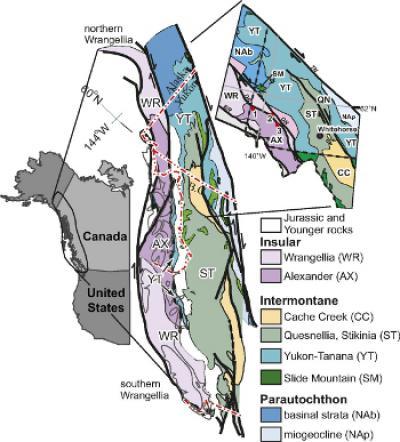
This is a Cordilleran terrane collage from S. Israel et al., August 2014.
(Photo Credit: Steve Israel and colleagues, Aug. 2014 issue of Lithosphere.)
Abstracts are online at http://lithosphere.gsapubs.org/content/early/recent. Representatives of the media may obtain complimentary copies of LITHOSPHERE articles by contacting Kea Giles at the address above.
Please discuss articles of interest with the authors before publishing stories on their work, and please make reference to LITHOSPHERE in articles published. Contact Kea Giles for additional information or assistance.
Non-media requests for articles may be directed to GSA Sales and Service, gsaservice@geosociety.org.
Tectonic control of topography, rainfall patterns, and erosion during rapid post Ma uplift of the Bolivian Andes
Kelin X. Whipple, School of Earth and Space Exploration, Arizona State University, Tempe, Arizona 85287, USA; and Nicole M. Gasparini, Dept. of Earth and Environmental Sciences, Tulane University, New Orleans, Louisiana 70118, USA. August 2014 issue; online at http://dx.doi.org/10.1130/L325.1.
Study of the deformation, erosion, and landscape evolution of the flanks of the Central Andean Plateau -- the region above 3 km elevation between 13 degrees and 27 degrees south that includes the Puna plateau, the Altiplano, and parts of the Eastern and Western Cordilleras and thus not restricted to internally drained regions -- is critical to testing provocative hypotheses regarding the timing, magnitude, and driving mechanisms of plateau surface uplift. As such, the style, rate, and timing of deformation in the Bolivian Andes -- the eastern flank of the Central Andean Plateau -- is of considerable interest to geologists, geophysicists, and geomorphologists interested in the interaction of processes in Earth's interior with those acting on its surface and, consequently, has been much debated.
Diagnosing climatic and tectonic controls on topography: Eastern flank of the northern Bolivian Andes
Nicole M. Gasparini, Dept. of Earth and Environmental Sciences, Tulane University, New Orleans, Louisiana 70118, USA, and Kelin X. Whipple, School of Earth and Space Exploration, Arizona State University, Tempe, Arizona 85287, USA. August 2014 issue; online at http://dx.doi.org/10.1130/L322.1.
Geologists have long debated whether high rainfall rates can drive high erosion rates that in turn drive high rock uplift rates. This process could potentially contribute to building and sustaining high relief in mountains, and it has been previously hypothesized that high rainfall rates are a primary control responsible for the high relief and morphology of rivers on the Beni escarpment in the Northern Bolivian Andes, a steep topographic step of approximately 3.5 km over a distance of 45 km. This study explores that hypothesis using previously published erosion rate data, along with rainfall rate and topographic data, and a computational landscape evolution model. The results show that high rainfall rates do not drive high erosion rates on the Beni escarpment. Instead, the data suggest that rock uplift rates increase into the escarpment and this pattern in rock uplift rate controls the pattern in erosion rates, which is independent of the rainfall pattern. The rainfall pattern does appear to affect the shape of river profiles, but it is a secondary control, and the rock uplift pattern is the primary control. Rainfall and rock uplift patterns cannot explain all of the changes in topography on the Beni escarpment, and rock type may also influence the shape of some river channels, however it does not appear to be influential in all cases. The study also presents guidelines for deciphering the role of climate and tectonics on the morphology of landscapes in other settings.
Geochronology of igneous rocks in the Sierra Norte de Córdoba (Argentina): Implications for the Pampean evolution at the western Gondwana margin
W. von Gosen et al., Geozentrum Nordbayern, Krustendynamik, Friedrich-Alexander-Universität Erlangen-Nürnberg, Schlossgarten 5, D-91054 Erlangen, Germany. August 2014 issue; online at http://dx.doi.org/10.1130/L344.1.
The easternmost segment of the Eastern Sierras Pampeanas unit in northwest Argentina is bordered in the east by the western pre-Andean Gondwana margin. Isotopic dating of different igneous rocks from the Sierra Norte de Córdoba combined with results of structural analyses permit to interpret the different stages of the Pampean evolution of this unit through time. Deposition of a thick pile of clastic sediments at the western Gondwana margin in the Neoproterozoic to Early Cambrian time interval is related to a passive margin, which presumably was underlain by west Gondwanan crust. East- to northeast-directed subduction beneath the west Gondwana margin was combined with the formation of a magmatic arc and compressive deformation in the upper (eastern) plate. A second-stage deformation with dextral mylonitization also in the Early Cambrian was accompanied by synkinematic intrusive activity. It can be related to intraplate compression due to ridge subduction and/or collision, which might have been followed by accretion of a continental terrane in the west. This was directly followed by uplift still in the Early Cambrian whereas subsequent igneous intrusions and extrusions indicate that the final stage of the Pampean evolution was terminated in the Middle Cambrian.
Eocene deep crust at Ama Drime, Tibet: Early evolution of the Himalayan orogen
Dawn A. Kellett et al., Geological Survey of Canada, Ottawa, Ontario K1A 0E8, Canada. August 2014 issue; http://dx.doi.org/10.1130/L350.1.
Rocks that were metamorphosed first at high pressure and then at high temperature can be found exposed in the Ama Drime massif, South Tibet, in the central-eastern part of the Himalayan collisional mountain belt. In this study, Ama Drime rocks were dated using two radiometric dating methods: Lu (lutetium )-Hf (hafnium) geochronology of garnet, and U (uranium)-Pb (lead) geochronology of zircon. Garnet from the three samples analyzed yielded approximate Lu-Hf ages of 37.5, 36.0, and 33.9 million years. Based on this, Dawn A. Kellett and colleagues estimate that the high pressure component of garnet in the rocks grew about 38 million years ago. This is the oldest age for burial of the lower Indian continental crust beneath Tibet reported from the central-eastern Himalaya. High-temperature metamorphism followed at about 15-13 million years ago, as indicated by their U-Pb zircon ages. Unlike ultra-high pressure rocks found in the northwest Himalaya, the Ama Drime rocks were not formed by rapid burial and exhumation of a cold subducted slab at the leading edge of the Indian plate as it began to collide with Asia. The rocks instead were buried and metamorphosed as continental crust thickened during the early stages of the still ongoing continental collision between India and Asia. They then resided in the lower-middle crust for more than 20 million years before being re-heated and ultimately exhumed to the surface. These new data provide solid evidence for Indian crust involved in the Himalayan collision having already reached at least ~60 km thickness by Late Eocene.
Source: Geological Society of America