Boulder, Colo., USA – Volcanic hazards aren't limited to eruptions. Debris avalanche landslides can also cause a great deal of damage and loss of life. Stratovolcanoes, with their steep, conical shapes made up of lava and unconsolidated mixed materials, can reach a critical point of instability when they overgrow their flanks. This leads to partial collapse, and the product of this slope failure is a large-scale, rapid mass movement known as a catastrophic landslide or debris avalanche.
In a matter of minutes, a debris avalanche can drastically modify the shape and nature of the surrounding landscape, covering extensive areas (in this case, up to 27 kilometers away) and changing the normal water drainage system of the region.
About 25 thousand years ago, the biggest slope failure event known at Taranaki volcano, New Zealand, resulted in the Pungarehu debris avalanche deposit (DAD). Initial collapse of the proto-Taranaki volcano occurred near the Last Glacial Maximum, with snow and ice cover and substantial groundwater present. The collapsing, sliding, large blocks of edifice material, known as "megaclasts," were highly fractured by the landslide generation and the depressurization event, forming pervasive jigsaw textures.
This study by scientists from Brazil, Mexico, and New Zealand provides a textural analysis of the unique features of this landslide. The authors examine grain sizes, sedimentary structures, and microscopic particle attributes and provide new insights into debris avalanche transport and internal evolution processes.
Their findings help to explain the formation of the highly irregular topography of debris avalanche deposits, with chaotically distributed (and probably temporary) zones of shear developing where softer lithologies occur in a collapsing mass, thus leading to differential velocity profiles of portions of the flowing mass in vertical and horizontal planes.
The authors write that their goal is not only to provide new insight concerning the transport and emplacement mechanisms of Pungarehu DAD, but to also improve understanding giant debris avalanche deposits worldwide.
FEATURED ARTICLE
Textural features as indicators of the transport and emplacement of the >7 km3 Pungarehu debris avalanche deposit, Taranaki volcano, New ZealandM. Roverato et al., Instituto de Geociências IGC GSA, Universidade de São Paulo, 05508080, São Paulo, SP, Brasil. Published online 30 June 2014; http://dx.doi.org/10.1130/B30946.1.
Other GSA BULLETIN articles (see below) cover such topics as
- 1. Helping to meet the land-management challenge of rapidly eroding gullies and arroyos caused by flash-flooding;2. One of the largest exposures of mantle rocks on Earth: The Betico-Rifean belt, southern Spain and northern Morocco;3. New mapping of the McDoogle pluton in the U.S. Sierra Nevada; and4. The formation and evolution of the Piling Group on Baffin Island, Canada.
GSA BULLETIN articles published ahead of print are online at http://gsabulletin.gsapubs.org/content/early/recent; abstracts are open-access at http://gsabulletin.gsapubs.org/. Representatives of the media may obtain complimentary copies of articles by contacting Kea Giles. Please discuss articles of interest with the authors before publishing stories on their work, and please make reference to GSA BULLETIN in your articles or blog posts. Contact Kea Giles for additional information or assistance.
Sign up for pre-issue publication e-alerts at http://www.gsapubs.org/cgi/alerts for first access to new journal content as it is posted. Subscribe to RSS feeds at http://gsabulletin.gsapubs.org/rss/.
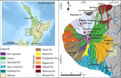
This is Figure 1 from Roverato et al.: Location map of the Taranaki peninsula and distribution of debris avalanche deposits surrounding Taranaki volcano, New Zealand.
(Photo Credit: GSA Bulletin and Roverato et al.)
Non-media requests for articles may be directed to GSA Sales and Service, gsaservice@geosociety.org.
Arroyo channel head evolution in a flash-flood–dominated discontinuous ephemeral stream systemStephen B. DeLong et al., U.S. Geological Survey, 345 Middlefield Road, Menlo Park, California 94025, USA. Published online 16 July 2014; http://dx.doi.org/10.1130/B31064.1.
Land managers in drylands across the world are challenged by rapidly eroding gullies and arroyos. Abrupt transitions from flat ground that conveys flood water as slow, wide, shallow flows to deeply eroding channels that convey water rapidly through the landscape have profound negative effects on rangeland quality. Surprisingly little is known about how the heads of arroyo channels erode and why their shapes mimic larger theater-shaped bedrock channel heads on Earth and other planets. Stephen B. DeLong and colleagues, by deploying a wide range of sensor technology, have illuminated the importance of surface floods both deep and shallow in causing erosion and expansion of these gully systems and conclude that water moving through the shallow subsurface and seeping out at steep channel heads, long thought to be a primary cause of theater-shaped channel heads, does not appear to be a necessary, or even common occurrence, in the studied landscape.
Crustal attenuation as a tracer for the emplacement of the Beni Bousera ultramafic massif (Betico-Rifean belt)A.M. Álvarez-Valero et al., Dept. of Earth, Atmospheric and Planetary Sciences, Massachusetts Institute of Technology, Cambridge Massachusetts, USA. Published online 30 June 2014; http://dx.doi.org/10.1130/B31040.1.
Earth's mantle, at high depths, is strikingly exposed in rare places on Earth's surface. This special situation requires the combination of different mechanisms in nature that allow such emplacement. The high temperature contact between the mantle rocks and those accompanists from the deep crust during their ascent, describe a particular picture in Earth's surface that needs an interdisciplinary study in detail of rocks and structures. Thereby, this paper focuses in the information given by the crustal rocks (partly melted at high temperatures), which are in turn coupled to the mantle rocks information, to constrain the emplacement process in one of the largest exposures of mantle rocks on Earth the Betico-Rifean belt (southern Spain and northern Morocco).
Multi-stage emplacement of the McDoogle pluton, an early phase of the John Muir intrusive suite, Sierra Nevada, CA, by magmatic crack-sealM.A. Stearns and J.M. Bartley, Dept. of Geology and Geophysics, University of Utah, Salt Lake City, Utah 84112, USA. Published online 30 June 2014; http://dx.doi.org/10.1130/B31062.1.
New mapping of the McDoogle pluton in the Sierra Nevada has resolved important details of its detailed intrusion history. The 95-million-year-old pluton is tabular and concordant to the steeply dipping surrounding rocks. It was previously divided into three phases (a central phase and two adjacent border phases) based on anatomy and rock type. The earliest central phase is made up of steep dikes separated by abundant inclusions of the wall rock. These screens are largely absent from border phases located on either side of the central phase. The inferred relative ages of intrusive phases and the wall-rock screen distribution mark a change from addition of new material at the margins (central phase) to addition at the center of each growing phase (border phases). Interaction between the effects of preexisting deformation, older non-deformed intrusions, and annealing likely caused the transition in growth mechanism. The trend from margin based to central based growth during emplacement has been observed in other intrusions and intrusive suites, and may be a general pattern of incremental intrusion associated with the feedback between preexisting deformation and thermal addition in magmatic arcs.
Did a proto-ocean basin form along the southeastern Rae cratonic margin? Evidence from U-Pb geochronology, geochemistry (Sm-Nd and whole-rock), and stratigraphy of the Paleoproterozoic Piling Group, northern CanadaN. Wodicka et al., Geological Survey of Canada, 601 Booth Street, Ottawa, Ontario K1A 0E8, Canada. Published online 16 July 2014; http://dx.doi.org/10.1130/B31028.1.
Approximately two billion years ago, an extensive sedimentary basin formed along the southern margin of the ancient Rae craton in northern Canada. This study uses field observations and analytical tools to elucidate the formation and evolution of the northeastern-most portion of this sedimentary basin, the Piling Group on Baffin Island, with the aim of deciphering the geological evolution of the underlying crust. The Piling Group contains deep marine turbidite deposits not observed in time-equivalent, intracratonic basin units further southwest. The work suggests that a proto-ocean basin formed off the southeastern coast of the Rae craton at about 1.92 billion years ago allowing for the deposition of 3-5 km thick turbidite deposits. Subsequent mantle upwelling may have triggered melting of highly thinned continental crust. The results are consistent with the much debated model of asthenospheric upwelling and incipient rifting along the Rae-Hearne boundary (Snowbird Tectonic Zone) farther southwest.
Calibration of a conodont apatite-based Ordovician 87Sr/86Sr curve to biostratigraphy and geochronology: Implications for stratigraphic resolutionM.R. Saltzman et al., School of Earth Sciences, Ohio State University, Columbus, Ohio 43210, USA. Published online 30 June 2014; http://dx.doi.org/10.1130/B31038.1.
The strontium isotopic composition of the world's oceans changes through time in response to weathering of rocks on the continents. One of the most prominent changes occurred in the Ordovician period between about 465 and 455 million years ago. This drop in Sr isotopes in the Ordovician can also be used to tell time because the element Sr is globally well mixed in the world's oceans.
Xigaze Forearc Basin revisited (South Tibet): provenance changes and origin of the Xigaze OphioliteW. An et al., State Key Laboratory of Mineral Deposits Research, School of Earth Sciences and Engineering, Nanjing University, Nanjing, 210029, China. Published online 30 June 2014; http://dx.doi.org/10.1130/B31020.1.
Studies on forearc-basin (a forearc is the region between an oceanic trench and the associated volcanic arc at Pacific-type convergent margins) are greatly helpful for understanding and reconstructing the evolution of the entire subduction system. This study investigated the Xigaze forearc basin, forming in the late Early Cretaceous (110 to 75 Ma [million years ago]) during the subduction of Neo-Tethyn Ocean in south Tibet. The geochemical and stratigraphic signatures indicate that the Xigaze Ophiolite formed by forearc spreading and represents the basement of the forearc sedimentary sequence. Volcaniclastic sedimentation began with thick turbiditic sandstones and interbedded shales followed by shelfal, deltaic, and fluvial strata. Studies of U-Pb-Hf isotopes of detrital zircons revealed that three petrofacies with distinct provenance document the progressive erosional evolution of the Gangdese arc with uplift of the central Lhasa during the Late Cretaceous.
Two-phase subduction and subsequent collision defines the Paleotethyan tectonics of the southeastern Tibetan Plateau: Evidence from zircon U-Pb dating, geochemistry, and structural geology of the Sanjiang orogenic belt, southwest ChinaT.N. Yang et al., Institute of Geology, Chinese Academy of Geological Sciences, Beijing 100037, China. Published online 16 July 2014; http://dx.doi.org/10.1130/B30921.1.
The Tibetan Plateau is the largest area on Earth today with rapid rates of modern deformation due to intracontinental convergence. Most of the convergence, perhaps more than two-thirds, has been absorbed by deformation within the Eurasian plate. However, its tectonic interpretation is still unsatisfied. One reason is the inherited complex anisotropy of the Tibetan crust developed during late Paleozoic to early Mesozoic (the Paleotethyan). Yang et al. proposed a tectonic model to interpret the assembly of crustal elements along the southeastern Tibetan Plateau on the basis of field observations and new dating results and geochemistry of magmatic rocks. The spatial and temporal distribution pattern of continental arc-like magmatic rocks suggest two phases subduction of paleo-oceanic crusts under continental blocks, which were subsequently followed by two phases continent-continent collision according to structural analyses. This study represents a major contribution of great significance and value, particularly to the large community of geoscientists trying to understand the evolution and current configuration of Asian lithosphere, as well as to anyone interested collisional tectonic processes and the geochemistry, structure and evolution of associated regional magmatic systems, as well as global paleogeographic reconstructions and their implications for plate tectonic configurations of the Mesozoic.
Himalayan gneiss dome formation in the middle crust and exhumation by normal faulting: New geochronology of Gianbul dome, northwestern IndiaF. Horton et al., Department of Earth Science, University of California, Santa Barbara, California 93106, USA. Published online 16 July 2014; http://dx.doi.org/10.1130/B31005.1.
Himalayan gneiss domes are prevalent -- yet seemingly paradoxical -- extensional features in the predominantly contractional India-Asia continental collision zone. Detailed structural observations and geochronology of Gianbul gneiss dome in the northwestern Himalaya indicate that doming occurred due to feedback among partial melting, positive buoyancy, and decompression as overlying crust extended. Doming ceased at >15 km depth, after which the dome was exhumed in the footwall of a brittle normal fault. These findings highlight the role of regional extension and partial melting during Himalayan orogenesis, and have implications for continental collision zones worldwide.
Source: Geological Society of America